

 South African Institute for Drug Free Sport Act, 1997
R 385
National Environmental Management: Protected Areas Act, 2003 (Act No. 57 of 2003)RegulationsAliwal Shoal Marine Protected Area RegulationsAnnexuresAnnexure 1 : (Zonation of Aliwal Shoal Marine Protected Area) |
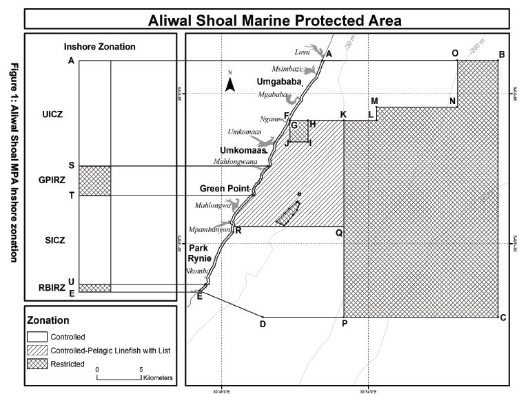
INSHORE
| (1) | Umkomaas Inshore Controlled Zone (UICZ) comprises the northern inshore portion of the Aliwal Shoal Marine Protected Area located north of the Green Point Inshore Restricted Zone and is defined as the area stretching 200 m seawards from the high water mark and along the high-water mark, between point A, which lies on the northern boundary of the Aliwal Shoal Marine Protected Area, near the south bank of the Lovu Estuary to point S, which lies at the northern end of the portion of the railway bridge which crosses over the Mahlongwana Estuary. |
| (2) | Green Point Inshore Restricted Zone (GPIRZ) comprises an inshore portion of the Aliwal Shoal Marine Protected Area between Greenpoint and the northern bank of the Mahlongwana Estuary (including Clansthal Beach and Hayes Rock) and is defined as the section 200 m seawards from the high water mark and along the high-water mark, between point S, which lies at the nothern end of the point of the railway bridge which crosses over the Mahlongwana Estuary and point T, which lies at the white beacon on Green Point Rocks. |
| (3) | Scottburgh Inshore Controlled Zone (SICZ) comprises the southern inshore portion of the Aliwal Shoal Marine Protected Area located between the two Inshore Restricted Zones, and stretching 200 m seawards from the high water mark and along the high-water mark, between point T, which lies at the white beacon on Green Point Rocks, and point U, which lies at the start of the rocky point at the southern end of the Rocky Bay Caravan Park. |
| (4) | Rocky Bay Inshore Restricted Zone (RBIRZ) comprises an inshore portion of the Aliwal Shoal Marine Protected Area and stretches 200 m seawards from the high water mark and along the high-water mark, between point U, which lies at the start of the rocky point at the southern end of the Rocky Bay Caravan Park and point E, which lies on the north bank of the Mzimayi Estuary at the southern boundary of the Aliwal Shoal Marine Protected Area. |
[Annexure 1(1)(2)(3) substituted by section 1(a)(b)(c) of Notice No. R.4210, GG49937, dated 22 December 2023 - (immediate effect)]
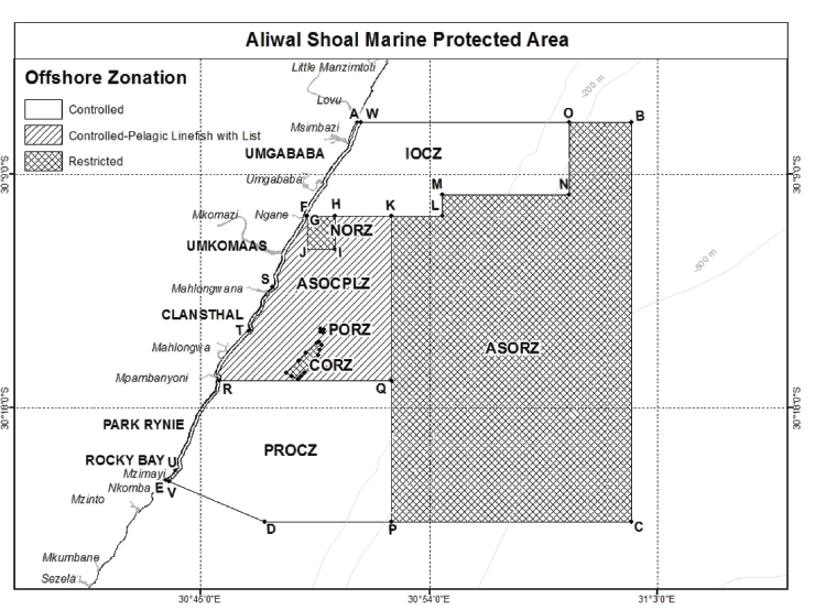
OFFSHORE
| (1) | Aliwal Shoal Offshore Restricted Zone (ASORZ) comprises an offshore portion of the Aliwal Shoal Marine Protected Area and is defined as the area within straight lines sequentially joining the points; K, L, M, N, O, B, C, P, Q and joining the first co-ordinate to the last. |
| (2) | Ngane Offshore Restricted Zone (NORZ) comprises of an offshore block within the Aliwal Shoal Marine Protected Area and is defined as the area within straight lines sequentially joining the points G, H, I, J and joining the first co-ordinate to the last. |
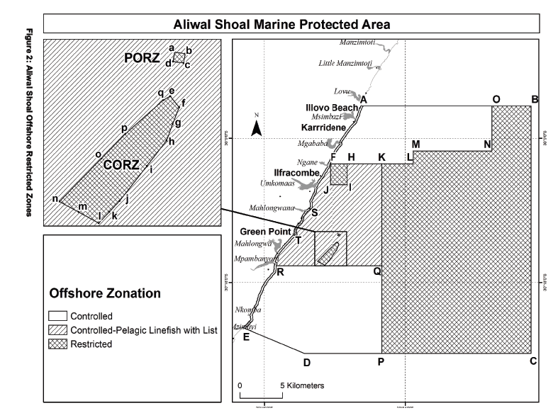
| (3) | Produce Offshore Restricted Zone (PORZ) is defined as the area including the wreck of the Produce vessel within straight lines sequentially joining the following four points: a, b, c, d and joining the first co-ordinate to the last. |
| (4) | Crown Offshore Restricted Zone (CORZ) comprises the Crown Area of Aliwal Shoal defined by the area enclosed by the following points, which lie approximately on the 25 meter isobath. The demarcation points are within straight lines sequentially joining the following: e, f, g, h, i, j, k, l, m, n, o, p, q and joining the first co-ordinate to the last. |
| (5) | Aliwal Shoal Offshore Controlled-Pelagic Linefish Zone (ASOCPLZ) comprises a central offshore portion of the Aliwal Shoal Marine Protected Area and is defined as the area seawards within straight lines sequentially joining the following points: F, K, Q, R and joining the first co-ordinate to the last, along the line 200 m from the high-water mark. This area starts beyond the inshore zones (which extend to 200 m offshore of the high water mark) and extends between the Ngane and Mpambanyoni Estuaries. |
| (6) | Illovo Offshore Controlled Zone (IOCZ) comprises the northern offshore portion of the Aliwal Shoal Marine Protected Area and is defined as the area within straight lines sequentially joining the following points: W, O, N, M, L, F and joining the first co-ordinate to the last along the line 200 m from the high-water mark. This area starts beyond the inshore zones (which extend to 200 m offshore of the high water mark). |
| (7) | Park Rynie Offshore Controlled Zone (PROCZ) comprises the southern offshore portion of the Aliwal Shoal Marine Protected Area and is defined as the area within straight lines sequentially joining the following points: R, Q, P, D, V and joining the first co-ordinate to the last along the line 200 m from the high-water mark. This area starts beyond the inshore zones (which extend to 200 m offshore of the high water mark). |
|
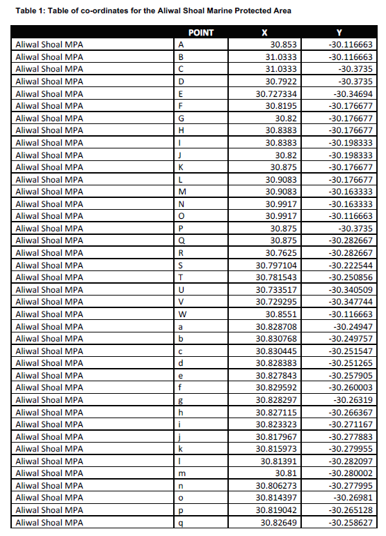
Aliwal Shoal MPA |
S |
30.79435162 |
-30.22484837 |
|
Aliwal Shoal MPA |
T |
30.78190617 |
-30.25055644 |
[Annexure 1(Table 1)(S)(T) substituted by section 2 (above) of Notice No. R.4210, GG49937, dated 22 December 2023 - (immediate effect)]


