

 Businesses Act, 1991 (Act No. 71 of 1991)
R 385
National Environmental Management: Protected Areas Act, 2003 (Act No. 57 of 2003)RegulationsAddo Elephant National Park Marine Protected Area RegulationsAnnexure 1 : Zonation for the Addo Elephant National Park Marine Protected Area |
| (1) | Addo Elephant National Park Marine Protected Area Offshore Zones: |
| (a) | St. Croix Island Offshore Restricted Zone (StCORZ) is defined, as the area from point J located on the line 200 m seawards from the high water mark, along the line 200 m seawards from the high-water mark to point U, and includes the area seawards within the following sequential straight line coordinates, U, H, G, F, E, D, C, P to J. |
| (b) | Sundays Offshore Controlled Zone (SOCZ) is defined, as the area from point J located on the line 200 m seawards from the high water mark along the line 200 m seawards from the high-water mark to point V, and includes the area seawards within the following sequential straight line coordinates, V, Q, R, O, P to J. |
| (c) | Bird Island Offshore Restricted Zone (BIORZ) is defined, as the area, from point V located on the line 200 m from the high-water mark, along the line 200m from the high-water mark to point W and includes the area seawards within the following sequential straight line coordinates, W, N, O, R, Q to V. |
| (d) | Cannon Rocks Offshore Controlled Zone (CROCZ) is defined, as the area from point W, located on the line 200m seawards of the high-water mark along the line 200m seawards of the high-water mark to Y and includes the area seawards within the following sequential straight line coordinates, Y, B, N, to W. |
| (2) | Addo Elephant National Park Marine Protected Area Inshore Zones: |
| (e) | Sundays inshore Controlled Zone (SICZ) includes the area from the highwater mark to 200m seawards of the high-water mark between point I at Hougam Park in the west, to point K east of the Sundays river mouth. |
| (f) | Sundays inshore Restricted Zone (SIRZ) includes the area from the highwater mark to 200m seawards of the high water mark from point K east of the Sundays river mouth to point L at the rope ladder at Woody Cape. |
| (g) | Cape Padrone inshore Controlled Zone (CPICZ) includes the area from the high-water mark to 200m seawards of the high water mark from point L at the rope ladder at Woody Cape in the West, to point M at Cape Padrone. |
| (h) | Cannon Rocks inshore Controlled Zone (CRICZ) includes the area from the high-water mark to 200 m seawards of the high-water mark between points M and A at the west end of Cannon Rocks. |
| (3) | Addo Elephant National Park Marine Protected Area Estuary Zones: |
| (i) | Sunday’s River Estuary Controlled Zone (SECZ) is defined, as that part of the Estuary up until the high water mark, from the mouth of the estuary upstream to the north western boundary of Ingleside town, at the Koppies, at point S |
| (j) | Sunday’s River Estuary Restricted Zone (SERZ) is defined, as that part of the Estuary up until the high water mark that starts at the north western boundary of Ingleside town, at the Koppies, at point S and runs upstream to point T at the Barkley Bridge. |
Zonation of the Addo Elephant National Park Marine Protected Are
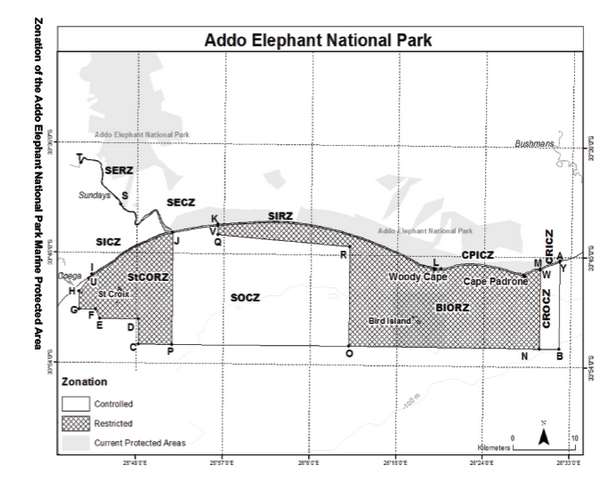
Annexure 1
(Zonation for the Amathole Offshore Marine Protected Area)
Kei Offshore Restricted Zone (KORZ) The KORZ is bounded by a series of straight lines sequentially joining the following coordinates, with the last line joining the last co-ordinate to the first: A, S, C, D, E, F, G, H, I, J, K.
Kei Offshore Controlled Zone (KOCZ) is bounded by a series of straight lines sequentially joining the following coordinates, with the last line joining the last coordinate to the first: A, B, S and S to A.
Gxulu Offshore Restricted Zone (GORZ) is bounded by a series of straight lines sequentially joining the following coordinates, with the last line joining the last co-ordinate to the first R, L, T, O, P, U, V, W, X.
Gxulu Offshore Controlled Zone (GOCZ) is bounded by a series of straight lines sequentially joining the following coordinates, with the last line joining the last co-ordinate to the first: R, X, W, V, U, Q.
Gxulu Offshore Controlled Pelagic Linefish Zone (GOCPLZ) is bounded by a series of straight lines sequentially joining the following coordinates with the last line joining the last co-ordinate to the first: L, M, N, T.
Fig. 1. The zonation for the Amathole Offshore Marine Protected Area.
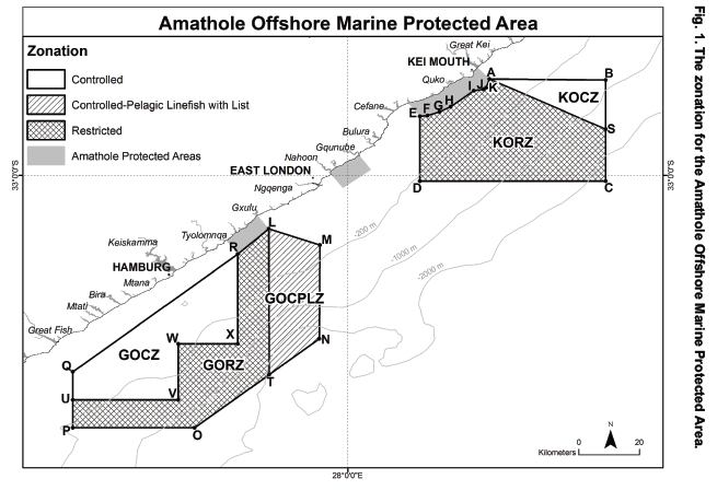
Table of co-ordinates for Addo MPA
|
Name |
POINT |
X |
Y |
|
Addo Elephant National Park MPA |
A |
26.5298 |
33.754122 |
|
Addo Elephant National Park MPA |
B |
26.5298 |
-33.875 |
|
Addo Elephant National Park MPA |
C |
25.8025 |
-33.875 |
|
Addo Elephant National Park MPA |
D |
25.8025 |
-33.84 |
|
Addo Elephant National Park MPA |
E |
25.7362 |
-33.84 |
|
Addo Elephant National Park MPA |
F |
25.728 |
-33.827333 |
|
Addo Elephant National Park MPA |
G |
25.7 |
-33.827333 |
|
Addo Elephant National Park MPA |
H |
25.7 |
-33.802983 |
|
Addo Elephant National Park MPA |
I |
25.721457 |
-33.779949 |
|
Addo Elephant National Park MPA |
J |
25.8609 |
-33.722156 |
|
Addo Elephant National Park MPA |
K |
25.9387 |
-33.710295 |
|
Addo Elephant National Park MPA |
L |
26.3243 |
-33.7672 |
|
Addo Elephant National Park MPA |
M |
26.496 |
-33.765595 |
|
Addo Elephant National Park MPA |
N |
26.496 |
-33.875 |
|
Addo Elephant National Park MPA |
O |
26.1667 |
-33.875 |
|
Addo Elephant National Park MPA |
P |
25.8609 |
-33.875 |
|
Addo Elephant National Park MPA |
Q |
25.9387 |
-33.72457 |
|
Addo Elephant National Park MPA |
R |
26.1667 |
-33.738807 |
|
Addo Elephant National Park MPA |
S |
25.771214 |
-33.683683 |
|
Addo Elephant National Park MPA |
T |
25.701352 |
-33.627685 |
|
Addo Elephant National Park MPA |
U |
25.716363 |
-33.785417 |
|
Addo Elephant National Park MPA |
V |
25.9387 |
-33.712187 |
|
Addo Elephant National Park MPA |
W |
26.495994 |
-33.767403 |
|
Addo Elephant National Park MPA |
Y |
26.5298 |
-33.756081 |


