| (1) |
A diagram intended to be approved by the Surveyor-General shall comply with the following requirements: |
| (a) |
It shall be prepared in black print of good quality on one or more sheets of good, durable paper on any of the following metric sizes: A0, A1, A2, A3 and A4: Provided that when a diagram comprises more than one sheet, a note to that effect and and the relevant sheet number shall appear in a prominent position on each sheet of the diagram; |
| (b) |
Only one side of the sheet shall be used; |
| (c) |
Margins shall be as follows: |
For A0, A1 and A2 diagrams a left-hand margin 40mm wide and all other margins 30mm, with the exception of the first sheet which shall have an additional column 180mm wide on the right-hand side which may be used for endorsements, and for A3 and A4 diagrams a left-hand margin 40mm wide and all other marings 10mm;
[Regulation 18(1)(c) substituted by section 7(a) of Notice No. 2249 of 2001]
| (d) |
Land shall be represented by a figure and be plotted to a standard scale: Provided that when beacons are in such close proximity to each other that their relative positions cannot be clearly shown, they shall be represented on an inset; |
| (e) |
The positions and designations of contiguous properties shall be indicated on the diagram; |
| (f) |
When it is necessary for the purpose of registration to represent on the diagram the boundaries of properties held under different tenures or conditions of title, such boundaries shall be represented by broken lines and shall be lettered; |
| (g) |
A diagram shall contain a clear and concise description of each beacon; |
| (h) |
All linear dimensions and co-ordinates recorded on a diagram shall be in metres to two decimal places; |
| (i) |
The following numerical data shall be recorded on a diagram: |
| (i) |
Co-ordinates of every corner point defining the rectilinear figure, every indicatory beacon, every corner point in respect of which connecting data are furnished, two favourably situated trigonometrical stations and, if applicable, sufficient points to uniquely identify a curve which forms part of a boundary: Provided that coordinates need not be stated on a diagram framed from an approved general plan, unless the co-ordinates of each corner point of the land concerned are stated on the said general plan; |
| (ii) |
The lengths of the sides of the rectilinear figure and, if applicable, the radius of every circular curve forming part of a boundary; |
| (iii) |
Angles of direction to the nearest one second of all sides: Provided that— |
| (a) |
when the length of the side is less than 1 000 metres the direction may be expressed to the nearest 10 seconds; |
| (b) |
when the side is part of a boundary, determined during the course of a survey, and whose length exceeds 1 000 metres, the direction of such side shall be expressed to single seconds; |
| (c) |
[Regulation 19(1)(i)(iii)(c) deleted by section 7(b) of Notice No. 2249 of 2001] |
| (d) |
angles may be recorded on the diagram of an erf if the erf is represented on an approved general plan on which angles are recorded; |
| (iv) |
The area, which shall be expressed in square metres to the nearest square metre when the area is less than one hectare, or in hectares to four decimal places if the area is equal to or greater than one hectare; |
| (v) |
Such data as may be necessary to define the limits of a figure representing a servitude; |
| (vi) |
Such connecting data as may be necessary to ensure that the figure represented on the diagram can be uniquely identified in relation to surrounding properties and to demonstrate that correct alignment of beacons has been established; |
| (j) |
The co-ordinate system and the constant by which the coordinates have been reduced shall be recorded; |
| (k) |
The numerical data recorded on a diagram shall be numerically consistent within the following limits: |
| (i) |
The closure of a data traverse computed round the rectilinear figure shall not exceed: |
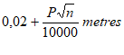
| (ii) |
The inconsistency in the area of the rectilinear figure as computed from its sides and angles, or directions, shall not exceed: |
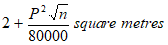
where p represents the perimeter in metres and n represents the number of sides of the rectilinear figure;
| (iii) |
The allowable maximum discrepancy in the recorded data of a curvilinear boundary shall be the area contained between the curvilinear line and a line parallel to it, displaced at a distance corresponding to one millimetre on the scale adopted for the plan referred to in regulation 18(1)(e)(iii); |
| (l) |
The direction of true north shall be indicated on each diagram; |
| (m) |
A clear definition of the limits of the figure shall be recorded as follows: |
| (i) |
In the definition shall be recorded, clockwise and in the order in which they occur, the letters or letters and numbers by which the corner points are indicated, and if applicable a description of the curvilinear boundary; |
| (ii) |
When a river, stream, water-course, wall, krans, or other well-defined permanent feature forms a new boundary, it shall be distinctly recorded in the definition of the figure which specific part of the feature forms such boundary; |
| (iii) |
Where the same piece of land consists of two or more parts and such parts meet at one or more common points, or such parts are disconnected by the prior deduction of a strip of road or railway reserve, the definition shall be recorded in such a manner as not to reflect separate figures. |
| (n) |
The designation of the figure, including references to the province, administrative district or registration division, township and local authority area, where applicable, shall be recorded: Provided that on a diagram compiled for consolidation of title, references to the component properties, together with the relevant diagram and deed numbers, shall be recorded, |
| (o) |
Each diagram shall contain such references as the Surveyor-General may require; |
| (p) |
The responsible land surveyor shall sign and date each sheet of a diagram and certify that it was either framed in terms of the proviso to section 16 of the Act, compiled for consolidation of title, or surveyed by him or her, as the case may be. The name of the land surveyor and his or her professional registration number shall also be recorded on the diagram. |
| (2) |
Notwithstanding the requirements of subregulation (1), a diagram compiled without resurvey for the purpose of consolidation of title, shall contain no numerical data other than the area, which shall agree exactly with the sum of the transfer areas of the component properties: Provided that complete numerical data may be reproduced from component diagrams where those diagrams contain such data on the same survey system: Provided further that beacon descriptions may be omitted where no numerical data are furnished. |
[Regulation 19(2) substituted by section 7(c) of Notice No. 2249 of 2001]
| (2A) |
Notwithstanding the requirements of subregulation (1) a diagram framed in terms of section 16 of the Act for deduction or noting purposes from an approved general plan, shall contain no beacon descriptions nor numerical data other than the area, which shall agree exactly with the area indicated on the general plan. |
[Regulation 19(2A) inserted by section 7(d) of Notice No. 2249 of 2001]
| (2B) |
All components of a compiled consolidation diagram must be based on the National Reference Framework, provided that the Surveyor-General may relax this requirement in exceptional circumstances. |
[Regulation 19(2B) inserted by section 2 of Notice No. 832 of 2014]
| (3) |
The Surveyor-General may refuse to approve any diagram should he or she be of the opinion that it is dilapidated, framed in a careless manner or its appearance is spoilt by amendments or additions. |


 Administration of Estates Act, 1965


