National Health Act, 2003
R 385
Income Tax Act, 1962 (Act No. 58 of 1962)Notices2013 NoticesNotice in terms of Section 13quat(8) of Income Tax Act, 1962 (Act No. 58 of 1962), of area demarcated by city of Cape Town as urban development zone |
Notice No. 147
27 February 2013
GG 36198
South African Revenue Service
I, Pravin Jamnadas Gordhan, Minister of Finance, hereby give notice in terms of section 13quat(8) of the Income Tax Act, 1962 (Act No. 58 of 1962), of the particulars of the area which has been demarcated as an urban development zone by the City of Cape Town as set out in the Annexure hereto, the municipality having proved that the area so demarcated complies with section 13quat(6) of the Income Tax Act, 1962 (Act No. 58 of 1962).
P.J Gordhan
Minister of Finance
Maitland extension to Cape Town Urban Development Zone - Description of Location and Position of Boundary
The Maitland extension , in terms of the urban renewal tax incentive (section 13quat of the Income Tax Act (Act No. 58 of 1962), is a contiguous polygon comprising broadly of four 'sides' (i.e. northern , eastern , southern and western edge). The boundary of the existing urban development zone forms the western edge of the proposed extension . The extension incorporates approximately 41.8 hectares. The boundary is defined as a continuous line following the course of designated streets and or boundaries of erven as noted below, commencing on the north-western corner, and continuing in a clockwise direction as follows:
Northern edge
| 1. | Extends eastward from existing urban development zone boundary across railway reserve and continues along southern edge of First Avenue (parallel to Voortrekker Road). |
| 2. | North along eastern edge of Sixth Avenue . |
| 3. | East along southern edge of Nyman Street. |
| 4. | East-North-East dogleg where boundary reaches Thirteenth Avenue, following northern boundary of Erf 113663. |
| 5. | East along southern edge of Dapper Road. |
Eastern edge
| 6. | South along western edge of Eighteenth Avenue. |
Southern edge
| 7. | Starting at intersection of Eighteenth Avenue and Voortrekker Road, boundary extends along property boundary forming northern edge of Voortrekker Road. |
| 8. | North along western boundary of Erf 23102. |
| 9. | West along southern boundary of Erf 162745. |
| 10. | South along eastern boundary of Erf 107455, which corresponds with western edge of Seventh Avenue . |
| 11. | Continue West along property boundaries forming northern edge of Voortrekker Road. |
| 12. | Follow northern boundary of Fourth Avenue so as to exclude Erf 22953, extend to north-eastern corner of Erf 22965. |
| 13. | South along eastern boundary of Erf 22965 until reaching northern edge of Voortrekker Road. |
| 14. | West along southern boundary of Erf 22965 and Erf 22960, and extend across rail reserve until reaching existing urban development zone boundary at south-eastern corner of Erf 22959. |
Allotment areas and townships included in the Maitland extension of the Cape Town urban development zone boundary:
Note that the following townships or portions thereof are included within the urban development zone boundary as defined above: in the Cape Town Administrative District and Cape Town Allotment Area , a portion of Kensington Estate (10707/1904), a portion of Kensington Estate Reserve (13051/1917), Kia Ora Township (A249/1931) and Janson Township (3311/1933).
Note that this list excludes proposed townships not yet established (i.e. where rezoning may be required within the urban development zone boundary).
Maitland extension to Cape Town UDZ: all erfs
|
Erf number |
|||
|
22685 |
22752 |
22960 |
114530 |
|
22686 |
22753 |
22961 |
116493 |
|
22688 |
22754 |
22962 |
139742 |
|
22689 |
22755 |
22963 |
140299 |
|
22690 |
22756 |
22965 |
141661 |
|
22691 |
22757 |
23065 |
148052 |
|
22692 |
22758 |
23102 |
149069 |
|
22693 |
22759 |
23135 |
151878 |
|
22694 |
22760 |
23239 |
153942 |
|
22695 |
22761 |
24058 |
157072 |
|
22696 |
22795 |
24771 |
158510 |
|
22697 |
22796 |
24773 |
159015 |
|
22700 |
22797 |
24863 |
162744 |
|
22701 |
22805 |
24864 |
162745 |
|
22702 |
22808 |
24885 |
163025 |
|
22703 |
22809 |
24888 |
163026 |
|
22705 |
22814 |
24919 |
163027 |
|
22709 |
22815 |
24924 |
163028 |
|
22710 |
22819 |
25164 |
163029 |
|
22711 |
22821 |
25169 |
163286 |
|
22712 |
22823 |
101628 |
164039 |
|
22718 |
22825 |
101704 |
164040 |
|
22720 |
22826 |
102147 |
166559 |
|
22722 |
22827 |
102240 |
166810 |
|
22723 |
22833 |
103695 |
168005 |
|
22725 |
22834 |
104148 |
168006 |
|
22727 |
22835 |
104149 |
169482 |
|
22729 |
22836 |
106175 |
170669 |
|
22730 |
22841 |
106320 |
172330 |
|
22738 |
22940 |
107455 |
174259 |
|
22740 |
22941 |
107933 |
|
|
22741 |
22944 |
107940 |
|
|
22742 |
22945 |
107941 |
|
|
22743 |
22947 |
107942 |
|
|
22745 |
22949 |
108540 |
|
|
22748 |
22951 |
109828 |
|
|
22750 |
22952 |
113663 |
|
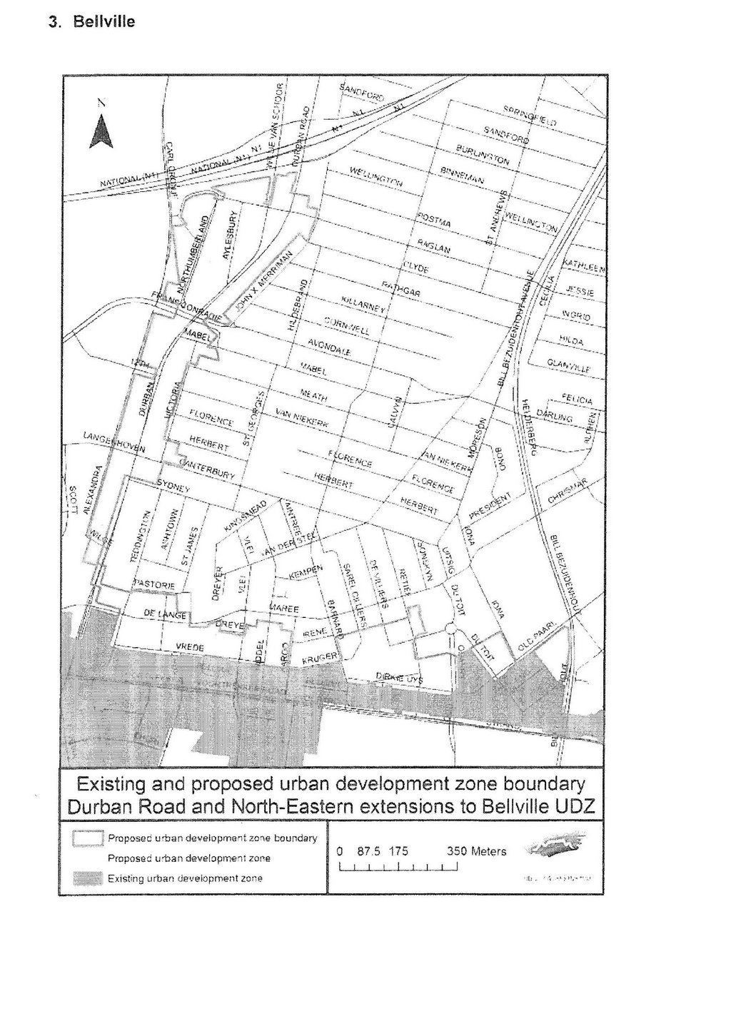
Parow extension to Bellville portion of Cape Town Urban Development Zone - Description of Location and Position of Boundary
The Parow extension, in terms of the urban renewal tax incentive (section 13quat of the Income Tax Act (Act No. 58 of 1962), consists of two polygons that form a corridor extending westward from the existing urban development zone in Bellville along Voortrekker Road until its intersection with Jan van Riebeeck/Giel Basson Drive. The description below describes the northern and southern edges of the larger Parow polygon of approximately 47.8 hectares, and the small A.J West Street polygon of approximately 0.5 hectare. The existing urban development zone boundary forms the eastern and northern edges of the Parow and A J Street polygons respectively . The boundary is defined as a continuous line following the course of designated streets and or boundaries of erven as noted below, commencing on the north-western corner, and continuing in a clockwise direction as follows:
Northern edge:
| 1. | Starting at the north-western corner of Erf 22326 and extending eastward along the northern property boundary. |
| 2. | Extending eastward along northern boundary of Erf 22595 , crossing Scott Road, along northern boundary of Erven 7649 and 7646, crossing Frankfort Road, along northern boundary of Erven 7629 and 7623, crossing Weimar Road, along northern boundary of Erven 19847, 7596 and 22574. |
| 3. | South along western edge of Ryan Road. |
| 4. | East along southern edge of Voortrekker Road. |
| 5. | North along eastern edge of Talent Road along western boundary of Erf 7554. |
| 6. | East along northern boundary of Erven 7554, 24586 and 7549, crossing Gardiner Road, along northern boundary of Erven 7529 and 7522, crossing Van Eyssen Road, along northern boundary of Erven 7498 and 7492, crossing Andries Pretorius Road, along northern boundary of Erven 7472, 7471, and 7436, crossing Wrensch Road, along northern boundary of Erven 7439 and 7436. |
| 7. | South along eastern boundary of Erf 7436. |
| 8. | East along southern edge of Voortrekker Road. |
| 9. | North along western boundary of Erf 7390. |
| 10. | East along northern boundary of Erven 7390 and 7389, crossing Smith Road, along northern boundary of Erven 7359, 7356, 7355, crossing Hopkins Road, along northern boundary of Erven 7339 and 7334. |
| 11. | South along eastern boundary of Erven 7334 and 7337. |
| 12. | East from south-eastern corner of Erf 7337 across intersection between Mcintyre and Voortrekker Roads, to south-western corner of Erf 7316. |
| 13. | North along western boundary of Erven 7316 and 10558. |
| 14. | East along northern boundary of Erf 10558. |
| 15. | South to midway point along eastern boundary of Erf 7305, where boundary crosses Fairfield-South Street to western boundary of Erf 4399. |
| 16. | East (broadly along southern edge of Wynne Road), following northern boundary of Erven 4399, 19041, 4406, 4407, 4408 and 22567, crossing McCarthy Street, along northern boundary of Erven 4423, 4425 and 4436, crossing Wendtlandt-South Road, along northern boundary of Erven 4442, 24576, 4446, 4447, 23420, crossing Glenboig-South Road, crossing northern boundary of Erven 4501, 4503, 4504, 4505, 4507 and 4510 . |
| 17. | South along eastern boundary of Erven 4510 and 451 6. |
| 18. | East from south-eastern corner of Erf 4516, across intersection of Voortrekker Road and Tierberg Road/De Ia Rey Street, to south-western corner of Erf 3413. |
| 19. | North along western boundary of Erven 3413 and 23122. |
| 20. | East (broadly along southern edge of Wynne Road), along northern boundary of Erven 23122, 3385, 22339, 3388, 3389, 2224 and 3392, crossing Provident-South Street, along northern boundary of Erven 22246, 3419, 3420, 3421, 3422, 3423, crossing Wessei-South Street, along northern boundary of Erf 21907. |
| 21. | South along eastern boundary of Erf 21907, corresponding with western edge of Toner-South Street. |
| 22. | East along northern edge of Voortrekker Road, from south-eastern corner of Erf 21907, crossing Toner-South Street, to south-western corner of Erf 3711. |
| 23. | South across Voortrekker Road to north-western corner of Erf 7803. |
| 24. | East along northern boundary of Erven 7803 and 7811, crossing Jones Street , along northern boundary of Erf 7832. |
| 25. | North, crossing Voortrekker Road, along western, northern and eastern boundary of Erf 3936, crossing Hampton Road along line extending from south-eastern corner of Erf 3936 and south-western corner of Erf 3717. |
| 26. | North and east along western and northern boundary of Erf 3717. |
| 27. | North across lnthlabati Road along western - and then northern - boundary of Erf 22407, along western - and northern - boundary of Erf 3715, crossing George Starck Road, along northern boundaries of Erven 3716 and 23452. |
| 28. | South-east along north-eastern boundary of Erf 23559 which corresponds with western edge of railway reserve. |
| 29. | East along northern edge of Voortrekker Road bridge, extending from south-eastern corner of Erf 23559 to south-western corner of Erf 15412. |
| 30. | North along eastern edge of Mike Pienaar Boulevard. |
| 31. | East along northern boundary of Erven 40130, along southern edge of Solway Street, crossing Broadway Street. |
| 32. | South along eastern boundary of Erf 10397. |
| 33. | East along northern boundary of Erf 10395. |
| 34. | South along eastern boundary of Erven 10395 and 10384. |
| 35. | East along northern boundary of Erven 10387 and 10388, crossing Duminy Street. |
| 36. | North along western boundary of Erf 10342. |
| 37. | East along southern edge of First Avenue , crossing Washington Street , Gladstone Street, Lincoln Street , Salisbury Street and Cleveland Street, terminating at western boundary of existing urban development zone . |
Southern edge:
| 38. | West from the south-western corner of Erf 10305, along the northern edge of Voortrekker Road, crossing Cleveland, Salisbury , Lincoln, Gladstone, Washington Street, Duminy and Broadway Street. |
| 39. | South from south-western corner of Erf 15411, crossing Voortrekker Road. |
| 40. | West along southern edge of Voortrekker Road, along northern boundary of Erven 10834 and 23986 and across bridge to north-eastern corner of Erf 15654, and south east along eastern boundary of Erf 15654. |
| 41. | West along southern boundary of Erven 15654, 7934 and 7946, crossing Boompies Street, along southern boundary of Erven 7933 and 7932, crossing Caxton Street, along southern boundary of Erven 22452, 23361, crossing Duminy Street, along southern boundary of Erf 21828, crossing Jenkinson Street, along southern boundary of Erf 7832, crossing Jones Street, crossing southern boundary of Erven 7814 and 7811. |
| 42. | North along western boundary of Erven 7811 and 7803. |
| 43. | West along southern edge of Voortrekker Road, crossing De La Rey Street as the boundary extends from the south-western corner of Erf 3413 to the south-eastern corner of Erf 7731. |
| 44. | South along eastern boundary of Erven 22429 and 17907. |
| 45. | West along southern boundary of Erf 17907, crossing Arnold Wilhelm Street, and along southern boundary of Erven 7721, 7720, 7736 and 7735, crossing Fritz Spilhaus Street , along southern boundary of Erf 24019, along southern edge of Voortrekker Road, along southern boundary of Erf 23383 , crossing Norden Street, along northern edge of Milner Road. |
| 46. | South along eastern boundary of Erven 9763, 9741 and 8923. |
| 47. | West along southern boundary of Erf 8923. |
| 48. | North along eastern edge of Picton Street, crossing at intersection with Voortrekker Road from north-western corner of Erf 9763 to north-eastern corner of Erf 9725 . |
| 49. | South along eastern boundary of Erven 9725, 9728, 9730 and 9733. |
| 50. | West along southern boundary of Erven 9733, 9367, 9369 and 9357. |
| 51. | North along eastern edge of Louis Trichardt Street, crossing at intersection with Voortrekker Road from north-western corner of Erf 9363 and north-eastern corner of Erf 9335, and South along western edge of Louis Trichardt Street. |
| 52. | West along southern boundary of Erven 9338, 22165, 9343,18127, 9345, 9347, crossing Station Street, continuing West along southern boundary of Erven 23438, 9320, 9323 , 9322, 22744, 9349 and 9351, crossing Klosser Street, along southern boundary of Erven 24186, 23381, 9295 and 20196, crossing Streenbras Street, along southern boundary of Erven 23449, 23178, 21810, 9282, 9280, 9284 and 9274, crossing Tygervallei Street, along southern boundary of Erven 9265, 23161, 9271,21722 and 9255, crossing Carstens Street, along southern boundary of Erven 22161, 92446, 9078, 9008, 9074, 9077 and 23376. |
| 53. | North along western boundary of Erf 23376, crossing Voortrekker Road, along western boundary of Erf 22326, terminating at north-western corner. |
A J West Street:
| 1. | Extends from south-eastern corner of Erf 10296, which corresponds with the existing urban development zone boundary, to the north-eastern corner of Erf 10877, thereby crossing Voortrekker Road. |
| 2. | South along eastern boundary of Erf 10877, West along southern boundary of Erven 10877 and 10870. |
| 3. | North along western boundary of Erf 10870, extending across Voortrekker Road and terminates at existing urban development zone boundary at the south-western corner of Erf 10302. |
Allotment areas and townships included in the Parow extension to the Bellville portion of the Cape Town urban development zone boundary:
Note that the following townships or portions thereof are included within the urban development zone boundary as defined above: in the Parow Administrative District and Parow Allotment Area, a portion of Glen Lily Estate (3722/1898}, a portion of the Township of Parow (6305/1902), a portion of Parow Township Extension 3 (3885/1956), a portion of Oostersee Township (5573/1958)and a portion of Samville Township (5669/1962).
|
Erf Numbers : Parow Allotment |
||||||||
|
3385 |
4399 |
7305 |
7596 |
9074 |
9313 |
9730 |
22294 |
24520 |
|
3388 |
4406 |
7312 |
7623 |
9077 |
9315 |
9733 |
22326 |
24575 |
|
3389 |
4407 |
7313 |
7624 |
9078 |
9316 |
9735 |
22339 |
24576 |
|
3392 |
4408 |
7316 |
7625 |
9243 |
9318 |
9740 |
22407 |
24586 |
|
3400 |
4412 |
7334 |
7626 |
9244 |
9320 |
9741 |
22429 |
|
|
3402 |
4415 |
7337 |
7628 |
9249 |
9322 |
9745 |
22452 |
|
|
3403 |
4416 |
7339 |
7629 |
9251 |
9323 |
9757 |
22466 |
|
|
3404 |
4420 |
7355 |
7646 |
9253 |
9326 |
9759 |
22567 |
|
|
3413 |
4422 |
7356 |
7647 |
9255 |
9328 |
9761 |
22574 |
|
|
3419 |
4423 |
7359 |
7648 |
9259 |
9330 |
9763 |
22595 |
|
|
3420 |
4425 |
7377 |
7649 |
9262 |
9334 |
10558 |
22744 |
|
|
3421 |
4436 |
7389 |
7720 |
9264 |
9335 |
15373 |
23121 |
|
|
3422 |
4438 |
7390 |
7721 |
9265 |
9336 |
15654 |
23122 |
|
|
3423 |
4440 |
7436 |
7729 |
9266 |
9338 |
16562 |
23161 |
|
|
3424 |
4442 |
7439 |
7730 |
9267 |
9339 |
16947 |
23169 |
|
|
3431 |
4443 |
7463 |
7731 |
9271 |
9343 |
17907 |
23170 |
|
|
3433 |
4446 |
7470 |
7735 |
9274 |
9345 |
18127 |
23178 |
|
|
3436 |
4447 |
7471 |
7736 |
9277 |
9347 |
19041 |
23361 |
|
|
3439 |
4453 |
7472 |
7788 |
9280 |
9349 |
19847 |
23376 |
|
|
3497 |
4458 |
7492 |
7791 |
9282 |
9351 |
20196 |
23381 |
|
|
3505 |
4459 |
7495 |
7803 |
9284 |
9353 |
21629 |
23383 |
|
|
3696 |
4501 |
7498 |
7811 |
9288 |
9357 |
21722 |
23420 |
|
|
3697 |
4503 |
7522 |
7814 |
9290 |
9363 |
21809 |
23438 |
|
|
3709 |
4504 |
7523 |
7832 |
9291 |
9367 |
21810 |
23449 |
|
|
3710 |
4505 |
7526 |
7932 |
9295 |
9369 |
21828 |
23452 |
|
|
3715 |
4507 |
7527 |
7933 |
9298 |
9721 |
21907 |
23559 |
|
|
3716 |
4510 |
7529 |
7934 |
9299 |
9722 |
22161 |
24019 |
|
|
3717 |
4516 |
7549 |
7946 |
9300 |
9724 |
22165 |
24146 |
|
|
3718 |
4521 |
7552 |
8923 |
9311 |
9725 |
22246 |
24186 |
|
|
3719 |
6984 |
7554 |
9008 |
9312 |
9728 |
22247 |
24482 |
|
In the Administrative District of Bellville and the Bellville Allotment Area, a portion of Bellville West Township (A5192/1928).
Note that this list excludes proposed townships not yet established (i.e.where rezoning may be required within the urban development zone boundary).
|
Erf Numbers : Bellville Allotment |
||
|
10306 |
10347 |
10479 |
|
10307 |
10348 |
10480 |
|
10308 |
10349 |
10482 |
|
10309 |
10350 |
10778 |
|
10310 |
10353 |
10870 |
|
10313 |
10355 |
10877 |
|
10314 |
10356 |
15398 |
|
10315 |
10357 |
15399 |
|
10316 |
10380 |
15400 |
|
10317 |
10381 |
15401 |
|
10318 |
10382 |
15402 |
|
10319 |
10383 |
15403 |
|
10322 |
10384 |
15411 |
|
10323 |
10385 |
15412 |
|
10324 |
10386 |
17482 |
|
10325 |
10387 |
25285 |
|
10326 |
10388 |
29035 |
|
10327 |
10389 |
31232 |
|
10329 |
10394 |
34818 |
|
10330 |
10395 |
35052 |
|
10331 |
10396 |
35800 |
|
10332 |
10397 |
39909 |
|
10334 |
10398 |
39917 |
|
10336 |
10399 |
40130 |
|
10338 |
10412 |
|
|
10339 |
10413 |
|
|
10341 |
10414 |
|
|
10342 |
10415 |
|
|
10343 |
10416 |
|
|
10344 |
10417 |
|
Durban Road extension to Bellville portion of Cape Town Urban Development Zone - Description of Location and Position of Boundary
The Durban Road extension , in terms of the urban renewal tax incentive (section 13quat of the Income Tax Act (Act No. 58 of 1962), consists of one polygon that forms a corridor extending northwards from the existing urban development zone in Bellville along Durban Road until its intersection with the N1 Freeway. The description below describes the western and eastern edges of the broadly linear polygon, and the northern edge of the Maree Street area which protrudes in an easterly direction from the southern portion of the Durban Road corridor proper. The southern boundary is formed by the existing urban development zone boundary. The polygon represents approximately 30.7 hectares. The boundary is defined as a continuous line following the course of designated streets and or boundaries of erven as noted below, commencing from the south-western corner, and continuing in a clockwise direction as follows:
Western edge of Durban Road extension:
| 1. | Extends from north-eastern corner of Erf 7703 - corresponding with the existing urban development zone boundary - to south-eastern corner of Erf 25291 , crossing De Lange Street. |
| 2. | West along southern boundary of Erf 25291 to south-western corner of Erf 25291 to south-eastern corner of Erf 7723, crossing Durban Road, and continuing along southern and then western boundary of Erf 7723. |
| 3. | North from north-western corner of Erf 7723 to south-western corner of Erf 5060, continuing along eastern edge of Alexandra Street, crossing Langenhoven Street. |
| 4. | East along southern edge of Twelfth Street. |
| 5. | North from north-eastern corner of Erf 4991 to south-eastern corner of Erf 4989, crossing Twelfth Street at intersection with Voortrekker Road, looping back along northern edge of Twelfth Street, before continuing North along western and then northern boundary of Erf 5072. |
| 6. | North from north-eastern corner of Erf 5072 to south-eastern corner of Erf 4403, crossing Frans Conradie Drive, and along southern, western and the northern boundary of Erf 4403, before extending to the mid-point of the western boundary of Erf 4423. |
| 7. | North along western boundary of Erven 4423 , 26993, 4420, 21549 and 4417 . |
| 8. | East along northern boundary of Erf 4417 , crossing Pioneer Street, to north western corner of Erf 4413, before curving eastwards along the western boundary of Erven 4413, 4414 and 4415, and northern boundary of Erven 4416 and 4407. |
| 9. | Extending from north-eastern corner of Erf 4407 to eastern corner of Erf 35194, crossing Raglan Avenue , and East along northern and then eastern boundary of Erf 35194. |
| 10. | Extending from south-eastern corner of Erf 35194 to south-western corner of Erf 4219, crossing Raglan Avenue, and North along eastern edge of Raglan Avenue. |
Eastern edge of Durban Road extension:
| . | East along northern boundary of Erf 4231 and 4221 , and South along western edge of Durban Road. |
| . | East from south-eastern corner of Erf 4227 to north-western corner of Erf 4238, crossing Durban Road, and along northern and then eastern boundary of Erf 4238 , and along northern boundary of Erf 4237, then extending to north-eastern corner of Erf 31231. |
| 13. | South along eastern and then southern boundary of Erf 31231, and in south westerly direction along south-eastern boundary of Erven 4489 , 4547, 4545 to 4543, 4541 to 4538, 4510 , 4534 to 4529, 4509 and 4527. This section thus incorporates the first row of properties abutting the eastern edge of Durban Road. South along eastern boundary of Erf 15746, then extending from south western corner of Erf 15746 to northern corner of Erf 15659, crossing Frans Conradie Drive, along eastern boundary of Erven 15759 and 4505 , then extending from south-eastern corner of Erf 4505 to north-western corner of Erf 5131, along western and then southern boundary of Erf 5131, and southern boundary of Erven 5133 and 17485, to south-eastern corner of Erf 24546, crossing Victoria Road. |
| 14. | South along western edge of Victoria Road, then extending eastward from southeastern corner of Erf 32142 to north-western corner of Erf 5346, then along eastern boundary of Erven 5346, 5347 and 5357, then West along southern boundary of Erven 5357, 5358, 24500- crossing Canterbury Street- then West along southern boundary of Erven 24500 and 5426 - extending in straight line to eastern boundary of Erf 25250. |
| 15. | South along western edge of Durban Road, then extending from north-eastern corner of Erf 7723 to north-western corner of 25291 , crossing Durban Road. |
| 16. | East along northern boundary of Erf 25291 , extending from north-eastern corner of Erf 25291 to north-western corner of Erf 15687, crossing Teddington Road. |
Maree Street protrusion:
| 17. | East along southern edge of Pastorie Road. |
| 18. | South along western edge of Louwville Street, but excluding Erven 7628 and 7626. |
| 19. | East along southern edge of De Lange Street. |
| 20. | South along western edge of Karoo Street , but excluding Erven 7541 to 7545, 7516 to 7517, 7590 and 7459 to 7461, and terminat ing at existing urban development zone boundary at the intersection of Karoo Street and Kruger Street. |
Allotment areas and townships included in the Durban Road extension to the Bellville portion of the Cape Town urban development zone boundary:
Note that the following townships or portions thereof are included within the urban development zone boundary as defined above: in the Bellville Administrative District and Bellville Allotment Area, a portion of Oakdale Township (13525/1903), a portion of Bellville Extension 2 (11598/1954), a portion of 3707/1898, a portion of Louwville Township (1640/1936), a portion of Kempenville Estate (A20254/1926) and a portion of Kempenville Township Extension (3634/1941).
Note that this list excludes proposed townships not yet established (i.e.where rezoning may be required within the urban development zone boundary).
|
Erf Numbers: Bellville Allotment |
||||||
|
4218 |
4438 |
4483 |
5072 |
7495 |
7658 |
32142 |
|
4219 |
4439 |
4484 |
5080 |
7506 |
7659 |
32776 |
|
4220 |
4442 |
4489 |
5084 |
7508 |
7660 |
32828 |
|
4221 |
4443 |
4505 |
5097 |
7514 |
7661 |
33106 |
|
4223 |
4444 |
4509 |
5098 |
7515 |
7662 |
34131 |
|
4226 |
4447 |
4510 |
5112 |
7518 |
7663 |
34856 |
|
4227 |
4448 |
4511 |
5117 |
7519 |
7664 |
35194 |
|
4231 |
4449 |
4527 |
5122 |
7524 |
7723 |
35195 |
|
4237 |
4450 |
4529 |
5131 |
7525 |
15390 |
35206 |
|
4238 |
4453 |
4530 |
5133 |
7526 |
15687 |
35638 |
|
4402 |
4454 |
4531 |
5346 |
7590 |
15739 |
36103 |
|
4403 |
4455 |
4532 |
5347 |
7624 |
15741 |
37289 |
|
4407 |
4457 |
4533 |
5357 |
7626 |
15746 |
39270 |
|
4408 |
4460 |
4534 |
5358 |
7628 |
17485 |
39684 |
|
4409 |
4461 |
4538 |
5410 |
7634 |
21242 |
39685 |
|
4410 |
4462 |
4539 |
5426 |
7635 |
21549 |
25291 |
|
4411 |
4463 |
4540 |
7462 |
7636 |
21583 |
|
|
4412 |
4464 |
4541 |
7463 |
7637 |
21631 |
|
|
4413 |
4465 |
4543 |
7464 |
7639 |
21634 |
|
|
4414 |
4466 |
4544 |
7467 |
7643 |
21690 |
|
|
4415 |
4467 |
4545 |
7476 |
7644 |
24500 |
|
|
4416 |
4468 |
4547 |
7478 |
7645 |
24546 |
|
|
4417 |
4469 |
4989 |
7479 |
7648 |
25249 |
|
|
4420 |
4470 |
4991 |
7480 |
7649 |
25250 |
|
|
4423 |
4471 |
5025 |
7487 |
7650 |
26401 |
|
|
4426 |
4472 |
5028 |
7488 |
7652 |
26993 |
|
|
4427 |
4474 |
5030 |
7491 |
7654 |
28958 |
|
|
4429 |
4475 |
5060 |
7492 |
7655 |
28962 |
|
|
4430 |
4476 |
5068 |
7493 |
7656 |
31231 |
|
|
4436 |
4477 |
5070 |
7494 |
7657 |
31633 |
|
North-eastern extensions to Bellville portion of Cape Town Urban Development Zone - Description of Location and Position of Boundary
The North-eastern extensions, in terms of the urban renewal tax incentive (section 13quat of the Income Tax Act (Act No. 58 of 1962), consist of three polygons that extend the north eastern edge of the Bellville urban development zone. These polygons are labelled 'De Villiers Street', 'Du Toit Street' and 'Bill Bezuidenhout Avenue' respectively, and are - in the same order - approximately 6.7, 1.2 and 1.1 hectares in size. The description below describes the boundaries of each of the three polygons, while the southern boundaries of all three polygons are formed by the existing urban development zone boundary . The boundary is defined as a continuous line following the course of designated streets and or boundaries of erven as noted below, commencing from the West and progressing towards the East.
De Villiers Street
| 1. | Extends from north-eastern corner of Erf 7446 (which corresponds with existing urban development zone boundary) diagonally across the Kruger and Barnard Street intersection to south-western corner of Erf 7390. |
| 2. | North along eastern edge of Barnard Street. |
| 3. | East along northern boundary of Erven 7392 and 7388, then crossing Sarel Cilliers Street, then along northern boundary of Erven 7380 and 7282, then crossing De Villiers Street, then along northern boundary of Erven 7289 and 34115, then crossing Retief Street, then - sequentially - along the western and northern boundary of Erf 39157. |
| 4. | South along eastern boundary of Erven 39157, 7260 and 7261, then extending from south-western corner of Erf 7261 to north-eastern corner of Erf 7278, crossing Retief Street, then continuing along western edge of Retief Street. |
| 5. | East from south-eastern corner of Erf 7275 to north-western corner of Erf 25176, crossing Retief Street, then along northern boundary of Erf 25176, until terminating at existing urban development zone boundary at the north-western corner of Erf 15410, crossing Quarry Road. |
Du Toit Street
| 1. | Extending from north-eastern corner of Erf 15410 (corresponding with existing urban development zone boundary) to north-western corner of Erf 18607, crossing Du Toit Street. |
| 2. | East along northern boundary of Erven 18607 and 7129. |
| 3. | South along western edge of lana Street, continuing in a straight line until terminating at existing urban development zone boundary along northern boundary of Erf 34084. |
Bill Bezuidenhout Avenue
| 1. | East from north-western corner of Erf 6992 (corresponding with existing urban development zone boundary) along southern edge of Old Paarl Road. |
| 2. | South along western edge of Bill Bezuidenhout Avenue, until terminating at existing urban development zone boundary at eastern corner of Erf 7020. |
Allotment areas and townships included in the North-eastern extension to the Bellville portion of the Cape Town urban development zone boundary:
Note that the following townships or portions thereof are included within the urban development zone boundary as defined above: in the Bellville Administrative District and Bellville Allotment Area , a portion of Kempenville Estate (A2025/1926), a portion of Lot M. (A4664/1927) , a portion of Maniesoord (2610/1945} , a portion of Bellville Extension 5 (7940/1956) and a portion of Avondstil Township (A987/1930).
Note that this list excludes proposed townships not yet established (i.e. where rezoning may be required within the urban development zone boundary).
|
Erf Numbers: Bellville |
|
|
6990 |
7391 |
|
6992 |
7392 |
|
7129 |
15410 |
|
7132 |
15957 |
|
7133 |
18607 |
|
7146 |
24418 |
|
7158 |
25176 |
|
7159 |
30869 |
|
7168 |
34080 |
|
7260 |
34115 |
|
7261 |
36046 |
|
7275 |
38028 |
|
7276 |
38029 |
|
7277 |
39157 |
|
7278 |
|
|
7279 |
|
|
7280 |
|
|
7281 |
|
|
7282 |
|
|
7289 |
|
|
7290 |
|
|
7291 |
|
|
7292 |
|
|
7380 |
|
|
7381 |
|
|
7382 |
|
|
7383 |
|
|
7388 |
|
|
7389 |
|
|
7390 |
|